Vous pouvez accéder à cet article (mis à jour) en français en cliquant ici
Ciel voilé Association, November 25, 2012
(The march 5th 2013 update allow you to observe some planes itinerary screenshots in differents countries by clicking the hilight links)
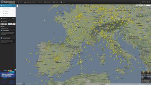
Air traffic is a concern, especially below 8 000 m altitude, and you would like to learn more about planes flying above you? Flight Radar will interest you. This is a website created in 2007 by Swedish, you'll see the planes that pass through your area, time is GMT. Click on one of them: its path is displayed in colors: pink 12 000 meters, 6000 meters blue. Colors depend on the altitude in meters.
At the top left of the picture you can change the scale (+ or - button) to view the whole path if the aircraft is coming from far away, from another country. On the left side of the screen you will find information about the aircraft: flight number, departure airport, arrival airport, altitude, speed, registration number. If you click on the registration number of the aircraft, you will discover that the flights of the last 30 days are recorded. Except that the playback and “live” scarcely resemble sometimes.
Air traffic controllers are responsible for air traffic from 8 000 m, below, it is the military that run. With increased traffic and flooding in their share of the sky, they collaborate cordially and productively with civil aviation.
For example, you follow on the screen a plane leaving Paris and moving to Marseille. But it’s way from Paris is rather below trade corridors: blue route rather than pink. On the Paris-Marseille-Paris, the playback (recording the flight) will only consider return Marseille-Paris: pink. Except that the "computer cleaner" cut back at some distance from the airport (since the plane did not land at Marseille) and thus the beginning of the path, which should correspond to an altitude takeoff, will have the wrong color: starting at 5000 m in the countryside for example.When the airport is by the sea, the "cut" paths start at sea and high altitude, dark blue for example.
You will also notice that often the departure and the arrival of the plane are not shown: top secret, private trip, freight, need confidentiality. But with patience, you can follow its whole journey on the screen. Sometimes the advertised departure or arrival does not correspond at all to the path on the screen: this is common, usual, banal.
Have you ever seen an airplane, far from the airport, making a loop and going back where it came from? The maneuver can be dangerous in a busy air corridor, impossible. But below 8,000 m, one can easily find on the site and observe in “live”. Above the sea turn is more discreet, but no need to hide when other companies do the same? No passengers on board, it does not bother anyone, right?
But which companies operate this way? If you think this applies only to low-cost companies, you are wrong: all major European airlines practice extensively and regularly. One should even say Mediterranean not to forget those in the South of the Mediterranean. Some places also record more than others turns of 180 °, usually two quarters of successive rounds. Furthermore European and Mediterranean airlines care about the European territory, but others coming from further afield do so. As you can see, Venezuela is not spared...
On the site of Flight Radar, the FAQ section includes the following question: “ Why when I am in the path of an airplane, suddenly it disappears?” Proposed response: "In most cases, the reason for this incident is that the coverage of the following receivers has been lost. This can also be a technical problem somewhere.” This is vague. Why nothing about an intentional disappearance?
It is the heart of the unknown activity of air traffic. Obviously certain movements, and not specifically military since they are commercial companies that are at work, do not have to be known to the general public. The "planer" trajectory is only one indication among many others. Why not let follow these planes going round and round? Know that you are detected when using Flight Radar. Perhaps a day will come when all loops will be hidden. In the meantime, enjoy. Who seeks finds.


/https%3A%2F%2Fi.ytimg.com%2Fvi%2FhNGDkdnPQYM%2Fhqdefault.jpg "Gironde: 42 000 hectares brûlés, 220 000 personnes évacuées, 2 soldats Morts au Feu...")
/https%3A%2F%2Fi.ytimg.com%2Fvi%2Fk45nHZ1fIaY%2Fhqdefault.jpg "L'interdiction de nommer, et comment reprendre la parole")
/https%3A%2F%2Fi.ytimg.com%2Fvi%2F1to42gyUVlc%2Fhqdefault.jpg "Un seul arbre : carburant, nourriture et médecine ?")
/https%3A%2F%2Fi.ytimg.com%2Fvi%2FGobWTIeLiVE%2Fhqdefault.jpg "UE-OTAN, une fin inéluctable")
/https%3A%2F%2Fi.ytimg.com%2Fvi%2FWF3WS3XqaDQ%2Fhqdefault.jpg "Carburant : le nerf de la guerre que la France n'a jamais vraiment quitté")
/image%2F1416990%2F20260728%2Fob_63a471_capture-decran-le-2026-07-27-a-15-01-1.png "La russophobie brûle les forêts d’Europe")
/https%3A%2F%2Fi.ytimg.com%2Fvi%2FnclxzKmT444%2Fhqdefault.jpg "La Chine recycle des montagnes de déchets grâce à de nouvelles technologies incroyables")
/https%3A%2F%2Fi.ytimg.com%2Fvi%2F7NZg3PRnbGo%2Fhq2.jpg "Vérification d'âge : le contrôle numérique va plus loin que vous ne le pensez.")
/https%3A%2F%2Fi.ytimg.com%2Fvi%2Fl2GbzMsKA5A%2Fhqdefault.jpg "Seyed M. Marandi : le pétrole saoudien brûle, Trump n'a aucune issue")
/https%3A%2F%2Fi.ytimg.com%2Fvi%2FdaDxIZPh-VM%2Fhqdefault.jpg "OTAN : LA VÉRITÉ DERRIÈRE L'ALLIANCE")
/image%2F1416990%2F20240322%2Fob_7a7c20_fig2.jpg)


